Address
304 North Cardinal St.
Dorchester Center, MA 02124
Work Hours
Monday to Friday: 7AM - 7PM
Weekend: 10AM - 5PM
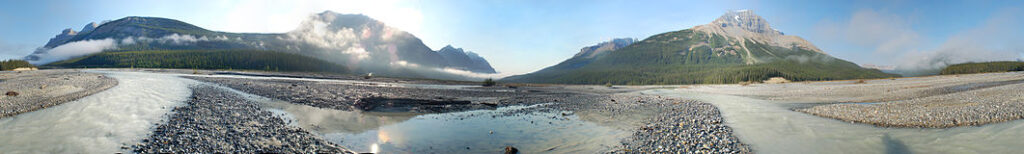
Driving Columbia Icefields Parkway through the scenic Canadian Rockies is MUST do and see.
This driving and sightseeing trip is one full day trip and provides you with time to take a few pictures and capture the sights and sounds forever in your memory. If you want to do something like serious hiking, canoe in Lake, you might need extra day for it.
If you have extra time, you can continue your journey towards the end of Icefield Parkway – Jasper International Park (104 km from Icefield Center).
A busy day awaits you, so it’s an early start from Lake Louise, or Town of Banff.
The Icefields Parkway begins two kilometers west of Lake Louise at a junction with the Trans-Canada Highway. Drive north on the Icefields Parkway #93.
This breathtaking drive way takes you all way to Jasper National Park.
The parkway lines up with beautiful turquoise lakes, tumbling waterfalls, ancient glaciers and the Columbia Icefields. It is rated as one of the top drives in the world by Condé Nast Traveller – the most beautiful picturesque drives in the world.
It is possible to travel this route in 3 hours, but it is very hard to do so because of the jaw-dropping scenery. Give a full day to the parkway so that you can stop and fully enjoy all the attractions it has to offer.
Get out early morning, you might be surprised to see some wildlife such as Big Horn Sheep, black bears, dear, elks, coyotes. If you are lucky, you might see mountains goats, or Grizzle bear.
Heading north of HWY #93 (Columbia Icefields Parkway) about 32 KM from Lake Louise , you will see Crowfood glacier on you left (west of the parkway).
Keep your eyes peeled in this area for the infamous Blondie, Banff National Park’s most visible grizzly bear.
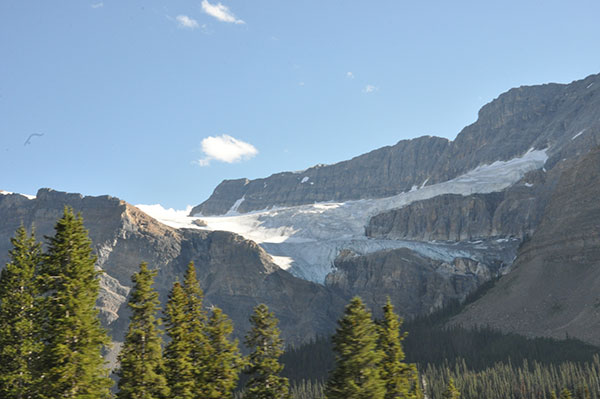
Does it look like a bird foot?
Crowfoot is a must-see stop on the parkway. Because rapidly changing climate forecasts are not optimistic for the glacier and we do not know how long it will last in its present form. So far the “third toe” was melted and barely visible.Opposite this spot is the Helen Lake trailhead. This popular hike is strenuous, but the reward is in the stunning mountain scenery. The best views of the Crowfoot Glacier are found further up the trail.
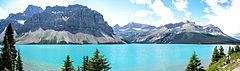
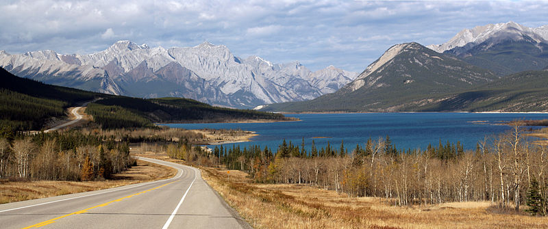
Just beyond Crowfoot Glacier are the crystal clear blue-green waters of Bow Lake with Num-ti-jah Lodge on its north shore.
Continue north along the Icefields Parkway for few minutes (4 km from Crowfoot viewpoint), you will see the views of Bow Lake.
First, there is a dedicated viewpoint. Next, there’s a turnoff for Num-Ti-Jah Lodge.
There’s an overlook right off the highway, but if you travel down the hill, there is another parking lot with access to a short trail. The trail takes you close to the lake, and you can follow the short loop along the lakefront, then circle back past the lodge to get to the parking lot again. The water is a spectacular color and the mountain scenery is top notch. The hike itself was less than 15 minutes – well worth the time.
The Bow Lake is fed by Bow Glacier Falls. Hiking to Bow Glacier Falls is MUST experience if you are outdoor lover and have half day. Click here where we share our Bow Glacier Falls hiking experience.
Bow Lake is part of the Icefields Parkway and is at 1920 m above sea level. It’s one of the smaller lakes in the National Park but it’s adjacent to the Bow River. It’s south of the Bow Summit where you can get great views of Wapta Icefield, Bow Glaciar, Mount Thompson and Crowfoot Glacier and Mountains.
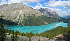
Bow summit is famous for its postcard viewpoint overlooking Peyto Lake.
Continue north on the parkway for 3 kilometers passing through open meadows and subalpine forest, and look for a parking area on the west (left) side of the parkway (it’s unmarked).
To reach the summit viewpoint, there is a relatively steep trail, from the parking lot, leads 1½ km through alpine forest to a scenic point above the timberline.
The viewpoint is allowed to drive to by handicapped people.
If you are not in rush, then continue up the well marked trail. Eventually, you will reach to a more primitive trail, but still fairly well marked. Then you end up on a wide rockpile with some great views of the lake. It will take you around extra half hour.
If you have couple hours to spend here, from viewpoint platform, climb another 3 km to Bow Summit Outlook which offers you stunning views of Peyto Lake, the rugged beauty of the Mistaya River valley stretching out, and a sea of distant peaks Columbia Icefields.
It is also great place for cross country skiing and snowshoeing in winter.
In winter please check the local avalanche bulletins and conditions.
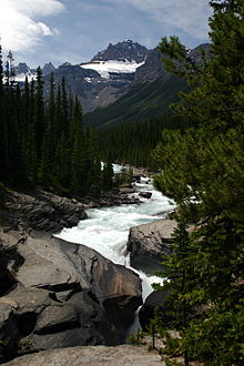
Keep going on the parkway towards north, Mistaya Canyon is well-signed on the Parkway about 34 KM north of Bow Summit. The pullout for parking at Mistaya Canyon is along the west side of road.
Follow the easy trail ( still too steep for wheelchairs), starting from the north of parking, down-hill for 0.5 KM, you will reach the bridge over the roaring Mistaya River.
Mistaya Caynon – Copyright Wikipedia
The river and the views at Mistaya Canyon are spectacular
Look straight down from the bridge, you will see powerful blue color of water flow constrained by smooth and narrow canyon walls.
Go right down on the rocks and take some photo shot, and sit down to have some drink, snak or picnic lunch, and enjoy ……
The canyon is deep and there are no railings. The trail is icy in early spring.
You will pass Saskatchewan River Crossing where is the meeting place of the waters of the Howse River, the Mistaya River and the North Saskatchewan. Very beautiful view.
Saskatchewan River Crossing – Copyright Wikipedia (Author: Henry Slofstra)
Keep eye on wildlife when you depart north from The Crossing.
From Saskaest (leftchewan River Crossing, head north on the Icefields parkway for 38 km, the Parkers Ridge parking lot is wt) of highway.
There is panabode privy at the parking lot, so that you may want to enjoy your picnic lunch there.
From parking lot, take a short and steep trail to the Parkers Ridge, where you will be rewarded with great views of the Saskatchewan Glacier – the longest tongue of ice flowing from the massive Columbia Icefields.
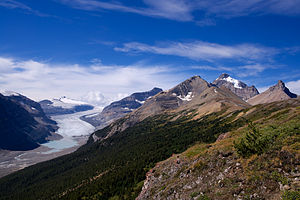
Saskatchewan Glacier – Copyright Wikipedia
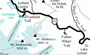
Finally, but not least, drive onto the Icefield Centre and enjoy ice walking on the Athabasca Glacier – a most accessible part of the Iefield.
It is walking distance from the Icefields parkway.
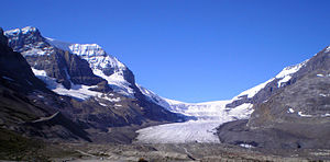
Athabasca Glacier – Copyright Wikipedia
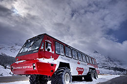
You can either walk up the trail from the parking area (cross road from the Center and follow the sign “Road to Glacier”) to the foot of Athabasca Glacier, or take the one and half hour snow bus tour (Ice Exploerer Adavanture) which will bring you right on to Athabasca Glacier, and you experience ice walking, just like you are in Ice Age.
Ice Explorer also brings you to a place where you can view more portion of ice field hidden beyond the mountains, which you cannot see from the edge / foot of Athabasca Glacier.
Be sure to dress warmly in layers, and wear hiking boots with good traction, bring sunglasses, because the reflection of the glacier is very strong.
Icefields Information Centre:
WARNNING: Never attempt to walk on the glacier yourself.
Hidden cliffs and holes covered by a thin layer of snow are very common – take one of the commercial tours.
There have been several deaths from people falling thru one of these thin layers of snow and either dying from the fall or freezing to death.
At your leisure drive back to Lake Louise or Banff, you could stop at historic Num-Ti-Jah Lodge, and enjoy drink or snack with beautiful view.
If you have extra time, you can continue your journey towards the end of Icefield Parkway – Jasper International Park (104 km from Icefield Center).
Click here for Banff area driving and sightseeing itineraries.